 Picture of Mount Everest
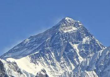
Tibet is the highest region on earth with an average elevation of 4,900 meters (16,000 ft). The region also is adjacent to the tallest mountain on earth in Mt. Everest, ( picture to the left) with an elevation of 8,848 meters (29,029 ft.) which is found in the mountain range known as the Himalayas. Tibet is considered to be a very mountainous region, however, it also contains some of the largest, and deepest canyons/valleys in the world. The Yarlung Tsangpo Grand Canyon, located along the Yarlung Tsangpo River, is a representation of this such occurrence.

This Diagram shows how the Himalayan mountains were formed, The Indian-Australian plate, and the Eurasian plate hit, and crashed into each-other for millions of years, and the crust builds up gradually as the Indian-Australian Plate pushes the Eurasian plate up. The Indo-Australian plate continues to move 67mm each year as it pushes further into Asia. Over the next 10 million years it will travel about 1,500 km into Asia. About 20mm per year of the India-Asia convergence is absorbed by thrusting along the Himalaya southern front. This leads to the Himalayas rising about 5mm per year, making them geologically active. The movement of the Indian plate into the Asian plate also makes this region seismically active, leading to earthquakes from time to time.
 Picture of the Mekong River
Tibet is divided into two main regions the "lake" and "river" regions. The "Lake region" is in the west-northwest portion, and the "river"region spreads out to three sides of the former east, south, and west. region names are useful in contrasting their different hydrological structures and also in contrasting their different cultural uses which is nomadic in the lake region, and agricultural in the river region. Despite its large size and mountainous nature, variation of climate across Tibetan Plateau is more steady than abrupt. The two main regions have different types of climate, the "river" region has a subtropical highland climate with moderate summer rainfall averaging about 20 inches per year. The daytime temperatures hang around 7 degrees Celsius (45 degrees Fahrenheit) in the winter, and 24 degrees Celsius (75 degrees Fahrenheit) in the summer months. The "river" region is characterized by its fertile mountain valleys and also is of course known for the many rivers such as the mekong and Yarlung Tsangpo and also some major tributaries located in the region.
 Picture of Pangong Tso Lake
The "lake" region is an arid and wide-swept desert. extends from the Pangong Tso Lake in Ladakh, Lake Rakshastal, Yamdrok Lake, and Lake Manasarovar near the source of the Indus river, to the sources of the Salween, the Mekong, and the Yangtze. region is also called the Chang Tang, or northern-plateau by the people of Tibet. It is some 700 mi broad, and covers an area about equal to that of France. Due to the extremely high mountain barriers it has a very arid alpine climate with an annual precipitation around 4 inches. The area is covered with large and small lakes, generally salt or alkaline in nature. The Chang Tang does contain discontinuous permafrost, so the soil is boggy and covered with tussocks of grass, thus resembling the Siberian tundra.
 Picture of Tibetan Buddhist monks
For thousands of years, despite its cold environment, the Tibetan people occupied this plateau and created cultural landscapes based on the principles of simplicity and non-violence that are in harmony with the environment. Guided by Buddhist beliefs in the interdependence of both living and non-living elements of the earth, Tibetans lived in harmony with nature. These beliefs are strengthened further by the Tibetan Buddhists traditional adherence to the principle of self-contentment: the environment should be used to fulfil one’s need and not to fulfil one’s greed. With the invasion of Tibet, the nature-friendly way of life for the Tibetan people was trampled upon by a materialist Chinese ideology. The invasion was followed by wide-spread environmental destruction in Tibet, resulting in deforestation, overgrazing, uncontrolled mining, nuclear waste dumping, nomads removal from the grasslands and other perils.
 Picture of Tibetan Antelope
Prior to the Chinese invasion, there existed a strict ban on the hunting of wild animals in Tibet. The Chinese have not enforced such restrictions. Indeed, the trophy hunting of endangered species has been actively encouraged. Rare Tibetan animals, such as the snow leopard are hunted for their fur and sold for large sums of money in the international market. In 1990’s a permit to hunt a rare Tibetan antelope is US$35,000 and an argali sheep US$23,000. Deer antlers, musk, bones and other parts of the wild animals are used in Chinese medicine. A large number of antelope, gazelle, blue sheep and wild yak are being poached by hunters to supply meat to markets in China, Hong kong and Europe. China is monopolizing international attention and using the giant panda to earn hard cash as well as to gain political leverage from influential countries, even as the species is threatened with extinction.
 This Picture shows the deforestation
in Tibet, Specifically in the upper
Yangtze river basin
This Picture shows the deforestation
in Tibet, Specifically in the upper
Yangtze river basin
Deforestation is also a huge problem for Tibet. Tibet had 25.2 million hectares of forests in 1959, but only 13.57 million hectares in 1985; a 46 percent drop. Regrettably, this figure grows each day. By China’s own estimate, up to 80 percent of the forests in Tibet have been destroyed. The Chinese have removed over US$54 billion worth of timber from Tibet (1959-1985) and, due to mismanagement; much of the wood has been simply left to rot on riverbanks or in logjams. Reforestation is minimal and is often unsuccessful. Massive deforestation, mining and intensified agricultural patterns in Tibet contribute to increased soil erosion. The Yangtze flood in the year 1998 which claimed the lives of thousands and resulted in a huge economic loss, was blamed by President Jiang Zemin on the rampant deforestation on the Tibetan Plateau. Additionally, scientists associate frequent floods that devastate Bangladesh as being directly associated with deforestation in Tibet.
 This picture shows the desertification present in Tibet This picture shows the desertification present in Tibet
Agricultural management is also a very big problem for the Tibetans, as a result of the failure of the Chinese government to be aware of environmental risks, Tibet's agriculture has suffered. During the 1960s, the Chinese imposed agricultural reforms on Tibetans in Tibet, which led to widespread famine throughout the country. High altitude overgrazing and intensive agricultural production has resulted in the loss of many medicinal herbs and food plants, and has destroyed much of the winter food supply. These programmes have also caused wind and water erosions, which leads to desertification. According to Chinese estimates, approximately 120,000 square kilometres in China and Tibet have become desert as a result of human activity. Of the available rangeland in Tibet, at least 30 percent is considered degraded. Chinese authorities reportedly are forcing Tibetan farmers to buy and use chemical fertilizers and insecticides. Tibetan farmers claim that these fertilizers are highly harmful to the crops as well as to the environment.
|
|
